Why Chicago Riverwalk matters.
Chicago Riverwalk is an expansive waterfront promenade where Chicago Loop's architectural heritage meets the engineering transformation of the Chicago River, the civic ambitions of Daniel Burnham and a contemporary public landscape that reconnects the city's commercial center with its defining waterway.
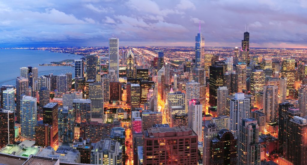
Stretching along the south bank of the Chicago River from Lake Shore Drive to Lake Street, the pedestrian promenade occupies the river's lower level beneath Wacker Drive, connecting the eastern waterfront near Michigan Avenue with the historic bridges and commercial towers of the Central Loop. Broad concrete terraces descend toward the water through a sequence of landscaped seating areas, stepped embankments and pedestrian passages beneath the city's movable bridges. The eastern sections establish an open relationship with the river's approach to Lake Michigan, with broad views of the Wrigley Building, Tribune Tower and the limestone bridgehouses that define the Michigan Avenue crossing. Farther west, the promenade narrows and expands between successive bridge structures, creating distinct waterfront rooms framed by steel trusses, masonry retaining walls and the reflective façades of surrounding skyscrapers. The result is a public landscape whose intimate relationship with the river, carefully engineered pedestrian connections and extraordinary architectural surroundings transform a historic transportation corridor into one of Chicago's most consequential civic spaces.
What defines Chicago Riverwalk.
Chicago Riverwalk is best known for transforming the Chicago River's industrial waterfront into a continuous public promenade through a century of engineering innovation, urban planning and architectural development. The river's earliest commercial importance emerged from Chicago's position between the Great Lakes and the Mississippi River watershed, where the construction of the Illinois and Michigan Canal in 1848 established a navigable connection between Lake Michigan and the Illinois River. The city's rapid industrial expansion subsequently turned the waterway into a major transportation corridor serving lumber yards, grain elevators, warehouses and manufacturing districts. Chicago's deteriorating sanitation conditions prompted an extraordinary engineering intervention in 1900, when the Chicago Sanitary and Ship Canal opened and reversed the flow of the Chicago River away from Lake Michigan. The Metropolitan Sanitary District directed the project, establishing one of the most ambitious hydraulic transformations in American urban history. Daniel Burnham and Edward H. Bennett subsequently presented the 1909 Plan of Chicago, envisioning a coordinated system of civic improvements that treated the river and lakefront as central elements of the city's metropolitan development. The construction of Wacker Drive during the 1920s introduced a multilevel roadway along the river's southern bank, separating commercial traffic from lower-level freight operations and creating the structural conditions for a future pedestrian waterfront. Architect Edward H. Bennett helped shape the roadway's expansive urban composition, which opened in 1926 and became a defining element of Chicago's downtown transportation network. The river's transformation continued through the twentieth century as industrial uses declined and major commercial towers replaced older warehouses and freight facilities along the waterfront. Chicago's renewed interest in public access culminated in a coordinated riverfront improvement program during the 2000s, connecting the city's historic planning ambitions to contemporary approaches to urban waterfront design.
Ross Barney Architects developed the contemporary Riverwalk through a collaboration with Sasaki Associates and Alfred Benesch & Company, translating the narrow space between Wacker Drive and the river into a sequence of distinctive public environments. The first major modern section, the Vietnam Veterans Memorial Plaza, opened in 2005 between State Street and Wabash Avenue, introducing a landscaped civic terrace honoring Illinois residents who served during the Vietnam War. Subsequent planning established a continuous pedestrian route through the remaining western sections, overcoming the challenge of bridge foundations that extended directly to the water's edge. The design team developed a system of underbridge connections, allowing pedestrians to pass beneath the movable bridges and experience the riverfront as an uninterrupted public corridor. Construction of the western expansion proceeded in phases beginning in 2014, with the Marina, Cove and River Theater sections opening in 2015. The Water Plaza, Jetty and Boardwalk followed in 2016, completing a six-block sequence extending west from State Street toward Lake Street. Each section responds to the river through a different spatial arrangement, including floating gardens, stepped seating, accessible waterfront platforms and landscaped areas supporting native aquatic vegetation. The Jetty incorporates ecological installations that introduce habitat for fish and other aquatic organisms, connecting the public landscape to ongoing efforts to improve the river's environmental conditions. The Boardwalk creates a broad pedestrian terrace beneath the elevated roadway, opening expansive views toward the confluence of the river's branches and the surrounding commercial skyline. The project received the American Institute of Architects' 2018 Honor Award for Regional and Urban Design, recognizing its integration of public infrastructure, architectural design and urban waterfront redevelopment. Chicago Riverwalk represents a major achievement in contemporary civic landscape architecture, transforming the river's historic commercial edge into a public environment shaped by engineering, ecological restoration and the city's longstanding architectural ambitions.
How Chicago Riverwalk fits.
Chicago Riverwalk works as the architectural centerpiece for an outing connecting the Chicago River's historic bridge engineering, the commercial skyscrapers that established its downtown prominence and the civic planning that transformed the waterway into a defining element of the modern city.
Begin at DuSable Bridge, the expansive double-deck bascule bridge carrying Michigan Avenue across the Chicago River. Completed in 1920, the bridge became a central component of the city's effort to connect the commercial Loop with the rapidly developing North Michigan Avenue corridor. Edward H. Bennett contributed to its architectural conception, integrating the crossing into the expansive civic language associated with the Plan of Chicago. Four sculptural reliefs on the bridgehouses depict significant episodes in Chicago's history, including the arrival of early explorers, the establishment of Fort Dearborn and the city's rebuilding after the Great Fire of 1871. The bridge's two-level roadway and movable steel spans exemplify the sophisticated engineering that allowed Chicago's commercial streets to coexist with a navigable industrial waterway. Continue to Chicago Architecture Center, the institution housed in the historic One Illinois Center complex beside the river. The organization originated in 1966 as the Chicago Architecture Foundation, established through the efforts of preservation advocates seeking to protect H. H. Richardson's Glessner House from demolition. Its headquarters relocated to the riverfront in 2018, creating a major public destination devoted to Chicago's architectural history and the global development of skyscraper design. The center's Chicago City Model Experience presents a detailed three-dimensional representation of the metropolitan skyline, connecting the city's architectural evolution to the engineering and planning decisions that shaped its urban form. Conclude at Merchandise Mart, the immense commercial building designed by Graham, Anderson, Probst & White and completed in 1930 at the confluence of the Chicago River's branches. Marshall Field & Company developed the structure as a centralized wholesale marketplace, consolidating furniture and merchandise showrooms within one of the largest commercial buildings ever constructed. Its Art Deco exterior incorporates limestone piers, decorative setbacks and expansive proportions, establishing a commanding presence above the river's north bank. The Kennedy family acquired the property in 1945, beginning a long period of ownership that connected the building to one of America's most prominent political families. The progression moves from DuSable Bridge's engineering and historical sculpture through Chicago Architecture Center's interpretation of the city's architectural development and culminates in Merchandise Mart's expansive commercial architecture, placing Chicago Riverwalk within the urban history that transformed the river into Chicago's defining downtown corridor.
Where your story begins.
Foresyte Travel reveals places that feel extraordinary long before you arrive.
Enjoy editorial crafted for luxury travelers.
Foresyte may earn a commission when you book.