
Why The Seaport matters.
The Seaport is a storied waterfront district where The Seaport's mercantile character meets preserved nineteenth-century streets, East River piers and contemporary architecture along one of Manhattan's oldest commercial shorelines.
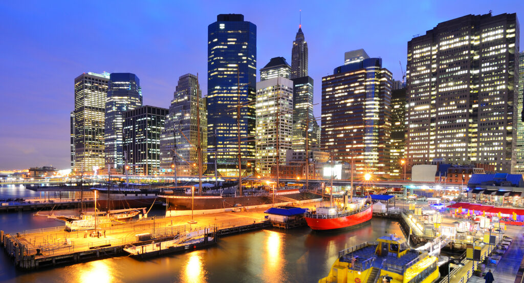
Set along South Street near Fulton Street and just steps from Peck Slip, the district occupies a compact East River enclave where low brick mercantile buildings, granite-edged streets and waterfront esplanades survive beneath the towers of Lower Manhattan. Georgian-Federal counting houses and later commercial structures hold the inland blocks close to their nineteenth-century scale before the street network opens toward broad river views and Brooklyn's opposite shore. Movement between Water, Front and South Streets follows short blocks once organized around wharves, slips, warehouses and maritime trades, keeping the historic shoreline legible within the present street pattern. The waterfront changes that compressed scale through broad piers and SHoP Architects' 300,000-square-foot Pier 17, whose open ground plane preserves sightlines toward the Brooklyn Bridge beneath an upper volume protected by custom sliding glass panels. The result is a district whose mercantile streets, surviving masonry, open piers and contemporary riverfront architecture preserve several centuries of New York's relationship with the East River inside a remarkably concentrated urban fabric.
What defines The Seaport.
The Seaport is best known for occupying the shoreline where New York developed from a colonial trading port into the nation's dominant nineteenth-century center of maritime commerce. Dutch settlement placed shipping activity along the East River during the seventeenth century, and successive grants permitted merchants to extend Manhattan through landfill, construct wharves and erect counting houses beside the new shoreline. By 1797, New York had become the largest port in the United States, setting the conditions for an extraordinary commercial expansion along South Street. Peter Schermerhorn secured a city water-lot grant in 1807 and built Schermerhorn Row between 1810 and 1812, combining storefronts, offices, warehouses and internal hoistways within a Georgian-Federal commercial block designed around rapid cargo handling. The Fulton Ferry began regular service between Manhattan and Brooklyn in 1813, placing commuters beside the merchants, sailors and laborers already crowding the waterfront. South Street merchants pioneered scheduled packet service across fixed routes in 1818, replacing departures dependent on fully loaded ships with predictable sailing dates that made Atlantic commerce and passenger travel substantially more reliable. Fulton Market opened in 1822, and its fish trade grew enough by 1831 for merchants to move closer to the East River landing used by fishing vessels. The wider port reached immense scale before the Civil War, receiving more than 4,000 vessels from foreign ports during 1860 alone as warehouses, chandlers, hotels, printers and financial businesses clustered behind the piers. Steamships and larger cargo volumes eventually shifted maritime activity toward the Hudson River, and the Brooklyn Bridge's 1883 opening weakened the East River ferry traffic that had sustained the district. Fulton Fish Market survived that decline for another century, operating on Fulton and South Streets until its 2005 relocation to Hunts Point ended a 183-year chapter of food commerce at the Seaport. Schermerhorn's counting houses, scheduled packet shipping, Fulton Ferry and Fulton Fish Market place The Seaport inside the commercial developments through which New York converted its natural harbor into national economic power.
Preservation created a second major chapter after declining maritime activity left much of the old port vulnerable to demolition during the twentieth century. The Seaport Museum was founded in 1967 as preservationists fought to retain the surviving waterfront fabric, and Schermerhorn Row received New York City protection in 1968. An urban-renewal plan approved in 1968 and 1969 paired restoration with new commercial and residential construction, followed in 1972 by National Register recognition and a special zoning district designed to support restoration through transferable development rights. The Landmarks Preservation Commission created the The Seaport Historic District on May 10, 1977, protecting a concentration of early nineteenth-century commercial architecture associated with shipping, immigration and commerce; a 1989 extension carried protection into another block bounded by Dover, Pearl and Water Streets and Peck Slip. Beyer Blinder Belle developed a 1980 master plan with the Museum and city development authorities, after which Benjamin Thompson & Associates and The Rouse Company advanced a pedestrian commercial district combining restored structures with new construction. The New Fulton Market opened in 1983 and a new retail complex on Pier 17 followed in 1985, placing James Rouse's festival-marketplace model inside the preservation project. Hurricane Sandy inundated the district in 2012 and forced another cycle of recovery before later waterfront investment remade its commercial edge. The surviving district now contains New York City's largest concentration of early nineteenth-century commercial buildings, giving the preservation campaign begun during the 1960s a physical legacy measured across entire streets.
How The Seaport fits.
The Seaport works as the anchor for an afternoon tracing Lower Manhattan through municipal architecture, the birthplace of the federal government and a Revolutionary-era tavern whose rooms later housed departments of the young United States.
Begin at City Hall, designed by Joseph François Mangin and John McComb Jr. after their proposal won an 1802 competition attracting 26 submissions. Construction began in 1803, slowed through labor disputes and a yellow-fever outbreak, and produced a Federal-style building with French influences that opened for municipal government in 1812. Stockbridge marble faced three sides, brownstone reduced costs on the north elevation, and ten Corinthian columns support the coffered dome and oculus above the interior rotunda. The building originally accommodated legislative, executive and judicial functions alongside courtrooms, small jails, a chapel and cellars, and it remains among the nation's oldest city halls still carrying its original governmental purpose. Continue to Federal Hall National Memorial, where New York's colonial City Hall became the seat of the new national government after Pierre L'Enfant remodeled the building in 1788. George Washington took the presidential oath on its second-floor balcony on April 30, 1789, and the First Congress subsequently created executive departments, organized the federal judiciary and sent twelve constitutional amendments to the states, ten of which became the Bill of Rights. The original building disappeared in 1812; the present Greek Revival structure opened as a United States Customs House in 1842 before becoming the federal Sub-Treasury in 1862, with gold and silver stored in basement vaults until that system ended in 1920. Conclude at Fraunces Tavern, where Étienne De Lancey constructed a brick house in 1719 before Samuel Fraunces purchased the property in 1762 and converted it into the Queen's Head Tavern. The Sons of Liberty used the building during the Revolutionary period, HMS Asia sent an 18-pound cannonball through its roof in 1775 and the New York Provincial Congress entertained Washington and his officers there in June 1776. British and American commissioners conducted the 1783 Birch Trials there during the evacuation of thousands of Black Loyalists, and Washington returned to the Long Room on December 4 for his farewell to Continental Army officers. Departments of Foreign Affairs and War and offices of the Board of Treasury occupied the building from 1785 to 1788, extending its significance directly into the Confederation government. The progression moves from Mangin and McComb's enduring seat of municipal government through the site where L'Enfant prepared the first national capitol into Samuel Fraunces's Revolutionary gathering place and Confederation offices, revealing how Lower Manhattan concentrated municipal, federal and military history within a remarkably small group of surviving sites.
Where your story begins.
Foresyte Travel reveals places that feel extraordinary long before you arrive.
Enjoy editorial crafted for luxury travelers.
Foresyte may earn a commission when you book.







































































































