Why Nuʻuanu Pali Lookout matters.
Nuʻuanu Pali Lookout is a dramatic mountain overlook where Nuʻuanu's volcanic geography meets the decisive 1795 Battle of Nuʻuanu, the consolidation of Kamehameha I's rule over Oʻahu and the towering windward cliffs that have shaped travel, warfare and settlement across the island.
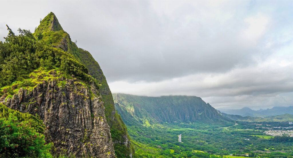
Positioned along the upper reaches of Nuʻuanu Valley beside the Pali Highway, the lookout occupies a narrow opening in the Koʻolau mountain crest, five miles northeast of Downtown Honolulu, overlooking the steep green slopes that descend toward Kāneʻohe and the windward coastal plain. Sheer volcanic cliffs frame the observation terrace, exposing deeply eroded ridges and narrow valleys beneath the summit. Persistent trade winds accelerate through the mountain gap, creating powerful gusts across the exposed viewing area. The surrounding landscape combines tropical vegetation, fractured volcanic rock and expansive views toward the northeastern shoreline. The result is a commanding mountain viewpoint whose dramatic terrain preserves the geographical conditions that shaped one of Hawaiian history's most consequential military confrontations.
What defines Nuʻuanu Pali Lookout.
Nuʻuanu Pali Lookout is best known for overlooking the battlefield where Kamehameha I defeated the forces of Oʻahu in 1795, securing control of the island during his campaign to unite the Hawaiian Islands. The Koʻolau mountain range originated as the eastern volcanic shield of Oʻahu, built through successive eruptions that accumulated extensive layers of basalt. The volcano's northeastern flank subsequently experienced immense geological collapse, creating a steep coastal escarpment that was further modified by erosion. Rainfall and stream activity carved deep valleys into the surviving mountain mass, establishing the rugged terrain surrounding the Nuʻuanu passage. The opening became an important route connecting the sheltered southern coast with the fertile windward districts. Hawaiian communities used mountain trails to transport goods, maintain political relationships and move between settlements separated by the Koʻolau crest. During the late eighteenth century, competing chiefly authorities contested control over the principal Hawaiian Islands. Kamehameha I consolidated his power on Hawaiʻi Island and subsequently extended his military campaigns across the archipelago. In 1795, his forces invaded Oʻahu after securing control of Maui and Molokaʻi. Kalanikūpule, the ruling chief of Oʻahu, organized resistance against the invading army. The opposing forces confronted one another in Nuʻuanu Valley, where Kamehameha's troops advanced toward the mountain passage. The battle involved traditional Hawaiian weapons alongside firearms and cannon introduced through increasing contact with European and American traders. Kamehameha's forces pushed the defenders toward the steep cliffs at the head of the valley. Numerous warriors fell or were driven over the precipice during the final stages of the confrontation. The victory ended Kalanikūpule's rule and established Kamehameha's authority over Oʻahu. Kauaʻi subsequently entered his kingdom through a negotiated submission in 1810, completing the political unification of the principal Hawaiian Islands. The Battle of Nuʻuanu became a defining event in the establishment of the Hawaiian Kingdom. The mountain passage retained its strategic importance as Honolulu expanded into the islands' principal political and commercial center. Nineteenth-century road improvements gradually replaced earlier footpaths, strengthening transportation between the island's southern and windward districts. Construction of the modern Pali Highway and its tunnels during the twentieth century redirected through traffic away from the historic mountain crest. The former road corridor subsequently became a public viewing area, preserving access to the dramatic landscape associated with the battle.
Kamehameha I's military campaign depended upon the strategic use of terrain, organized forces and weapons acquired through expanding maritime trade. His army included experienced Hawaiian warriors whose knowledge of mountain routes and valley approaches shaped the advance across Oʻahu. The narrow geography of Nuʻuanu concentrated the retreating defenders near a precipice that offered limited opportunities for escape. The surviving escarpment rises hundreds of feet above the windward valleys, revealing the physical conditions that made the battle's conclusion so devastating. The lookout stands at an elevation of 1,200 feet, providing an extensive view across the northeastern side of the island. The Koʻolau cliffs consist principally of volcanic basalt exposed through prolonged weathering and erosion. Their steep faces support vegetation adapted to persistent moisture, cloud cover and the island's prevailing trade winds. Air moving across the Pacific encounters the mountain barrier and rises along its windward slopes, producing substantial rainfall through orographic precipitation. The resulting moisture supports the dense green vegetation characteristic of northeastern Oʻahu. Wind accelerates through gaps in the mountain crest, producing the powerful gusts associated with the lookout. The observation terrace provides views across the agricultural and residential landscapes of Kāneʻohe and the surrounding coastal districts. Kāneʻohe Bay extends toward the offshore reef, whose protected waters form one of the island's most extensive marine environments. The distant shoreline reveals the relationship between the mountain escarpment and the coastal plain created through geological and sedimentary processes. Interpretive displays connect the visible terrain with the historical events of the Hawaiian unification campaigns. The surviving alignment of the Old Pali Road preserves a connection with nineteenth- and twentieth-century transportation engineering. Its former roadway followed the steep mountain slopes before modern tunnels provided a more direct crossing beneath the ridge. The lookout's combination of historical interpretation, exposed geology and sweeping coastal views establishes a direct connection between the island's natural formation and the political events that shaped the Hawaiian Kingdom.
How Nuʻuanu Pali Lookout fits.
Nuʻuanu Pali Lookout works as the historical and geographical anchor for a Honolulu outing connecting Hawaiian royal institutions, nineteenth-century missionary history and the preserved landscapes of the island's windward coast.
Begin at Queen Emma Summer Palace, the historic royal residence situated along the lower reaches of Nuʻuanu Valley. Known as Hānaiakamalama, the property served as a retreat for Queen Emma, King Kamehameha IV and their son, Prince Albert, during the nineteenth century. Its architecture combines Hawaiian royal domestic traditions with Western residential influences introduced during the kingdom's international expansion. Preserved furnishings, portraits and personal possessions illuminate the lives of the royal family and the social institutions of the Hawaiian monarchy. The surrounding grounds retain mature tropical vegetation associated with the valley's cooler, wetter climate. Continue to the Hawaiian Mission Houses Historic Site and Archives, situated near the historic civic center of Downtown Honolulu. The complex preserves early nineteenth-century buildings associated with Protestant missionaries who arrived in Hawaiʻi beginning in 1820. The Mission House, constructed in 1821, represents one of the oldest surviving Western-style buildings in the islands. Its historical collections examine the introduction of printing, literacy programs and educational institutions during the Hawaiian Kingdom's formative decades. The site also addresses the complex relationships between missionary activity, Hawaiian political authority and changing religious practices. Conclude at Hoʻomaluhia Botanical Garden, the expansive public garden situated beneath the Koʻolau cliffs in Kāneʻohe. Established in 1982, the garden occupies a substantial landscape developed for flood protection and botanical conservation. Its collections include tropical plants from regions across the world, arranged within distinct geographical planting areas. Walking routes pass broad lawns, forested slopes and a reservoir framed by the steep volcanic ridges. The garden's location provides an intimate perspective on the geological escarpment and rainfall patterns that define windward Oʻahu. The progression moves from Queen Emma Summer Palace's royal domestic history through Hawaiian Mission Houses Historic Site and Archives' nineteenth-century institutional development and culminates at Hoʻomaluhia Botanical Garden's windward landscape, connecting Nuʻuanu Pali Lookout with the historical and environmental foundations of Oʻahu.
Where your story begins.
Foresyte Travel reveals places that feel extraordinary long before you arrive.
Enjoy editorial crafted for luxury travelers.
Foresyte may earn a commission when you book.