
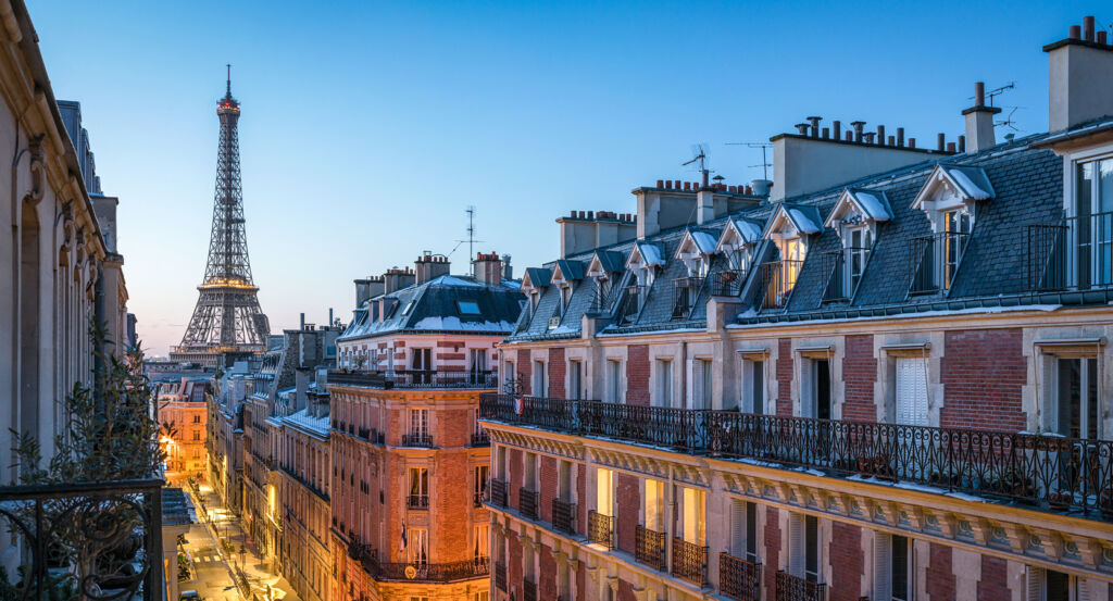
Why Gros-Caillou matters.
Gros-Caillou is a distinguished enclave where the Seine meets the western Left Bank through village-scaled commercial streets, grand residential avenues and an extraordinary concentration of architecture formed between royal expansion and the great building campaigns of modern Paris.
Positioned between Invalides, École Militaire, and the Seine, the neighborhood occupies a broad western pocket where Rue Saint-Dominique, Rue de Grenelle and Rue de l'Université extend toward Champ-de-Mars through territory that remained fields, vineyards and woodland into the seventeenth century. Narrower streets around Rue Cler and Rue du Gros-Caillou preserve an intimate physical scale inside a district otherwise marked by long avenues, substantial apartment buildings and expansive river frontage. Rue Saint-Dominique establishes the primary encounter through a continuous commercial corridor whose shops, restaurants and residential facades carry the neighborhood east toward the ceremonial architecture surrounding Invalides. Avenue Rapp and the streets approaching the Seine deepen the physical character through elaborate turn-of-the-century apartment houses, secluded squares and glimpses toward the river between densely built blocks. Champ-de-Mars opens the western edge into a vast landscape, producing a dramatic release from the compact streets that developed across the former Grenelle plain. The result is a neighborhood whose unusual shifts of scale preserve the transition from peripheral settlement to metropolitan Paris, preparing a history that began when royal construction drew workers and craftsmen onto previously rural ground.
What defines Gros-Caillou.
Gros-Caillou is best known for emerging from the rural eastern edge of the Grenelle plain after major royal building projects pulled workers, craftsmen and commercial activity westward from established Paris. Fields, vineyards, gardens and hunting ground covered the territory into the seventeenth century, and early references to Gros-Caillou appear in 1510 and 1523, when the area was also associated with the name Vert-Buisson. One explanation for the surviving name connects it to a large stone marking the boundary between lands controlled by Saint-Germain-des-Prés and Sainte-Geneviève, fixing a territorial division into local geography. Construction of the Hôtel des Invalides under Louis XIV became the decisive catalyst for settlement as laborers established themselves along Rue Saint-Dominique and Rue de Grenelle. Building activity later spread toward the port on the Seine, and workers connected with the Palais Bourbon and École Militaire enlarged the population established across the former fields. Timber yards at the Grenouillère and river commerce added employment close to the port, supporting artisans beyond the major royal works. Washerwomen, taverns and cabarets followed the growing labor population during the eighteenth century, giving the emerging settlement a social infrastructure distinct from the aristocratic faubourgs farther east. By the century's end, Gros-Caillou had moved from open ground at Paris's edge into a substantial working settlement tied to construction, river commerce and craft labor.
Changes along the Seine supplied a separate mechanism for carrying Gros-Caillou into the industrial and metropolitan city. Part of the neighborhood occupied the former Île des Cygnes, separated from the mainland by the Petite Seine until filling began in 1786 and eliminated the remaining channel by 1812, with a section of Rue de l'Université following its former course. Nineteenth-century industry then concentrated beside the river, led by the Gros-Caillou tobacco factory on Quai d'Orsay, an operation employing more than one thousand workers before its closure in 1905. Government storehouses, military supply facilities and other large establishments occupied adjoining riverside parcels, reinforcing the productive character of the eastern neighborhood. Second Empire construction introduced Avenues Rapp and Bosquet through the inherited fabric, establishing broad axes between the interior streets and the Seine. Demolition of the tobacco factory in 1909 released another major tract for residential development, joining the subdivision of former industrial ground to the apartment construction advancing around the new avenues. Gros-Caillou entered the twentieth century with its older working streets embedded inside a newer residential district created through the disappearance of river channels, factories and extensive institutional parcels.
How Gros-Caillou fits.
Gros-Caillou works as the anchor for an afternoon tracing Parisian Art Nouveau, an expatriate religious institution and the engineering system that fundamentally changed the sanitation of the nineteenth-century capital.
Begin at Immeuble Lavirotte, where architect Jules Lavirotte created one of Paris's most concentrated Art Nouveau facades at 29 Avenue Rapp in 1900 and 1901. Ceramicist Alexandre Bigot contributed the elaborate fired-clay surface, and sculptural work around the entrance brought human figures, vegetation and architectural ornament into a composition extending across windows, balconies and the extraordinary portal; a surviving wooden model associates Lavirotte with sculptor Jean-Baptiste Larrivé, and the completed facade won the City of Paris facade competition in 1901. Continue to American Church in Paris, whose congregation traces its origins to American Protestants gathering in the city in 1814 before receiving an official charter and first purpose-built sanctuary on Rue de Berri in 1857. Growth eventually pushed the congregation toward Quai d'Orsay under pastor Joseph W. Cochran, with construction of the present sanctuary beginning on March 1, 1926 and dedication following on September 6, 1931; its plan draws on fifteenth-century Gothic church architecture, and the institution became the first American church founded beyond the United States. Conclude at Musée des Égouts de Paris, where the underground infrastructure engineered during the Haussmann era becomes accessible inside the functioning sewer network near Pont de l'Alma. Eugène Belgrand took charge of the Paris water service in 1854 and developed an integrated system carrying wastewater and rainwater beneath the expanding capital, with spring water entering the city from 1865 and public sewer excursions beginning during the 1867 Exposition Universelle; the museum opened at the Alma facility in 1975, preserving cleaning machinery and access to working collectors within a network now extending for close to 2,600 kilometers. The progression moves from Lavirotte and Bigot turning an apartment facade into an Art Nouveau collaboration through an American congregation establishing a permanent Paris sanctuary into Belgrand reorganizing the hidden infrastructure beneath the capital, connecting architectural experimentation, international religious life and metropolitan engineering across Gros-Caillou.
Where your story begins.
Foresyte Travel reveals places that feel extraordinary long before you arrive.
Enjoy editorial crafted for luxury travelers.
Foresyte may earn a commission when you book.














































































































