
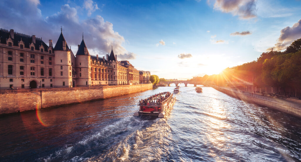
Why Seine matters.
Seine is a foundational Parisian waterway where Central Paris's urban form meets more than two millennia of settlement, commercial navigation, grand bridge building and an architectural riverfront recognized as a UNESCO World Heritage Site.
Set across Paris between the eastern boundary near Charenton-le-Pont and the western reach approaching Issy-les-Moulineaux, the river occupies a 13-kilometer course through the capital between dense neighborhoods rising from both banks and the islands embedded within its historic center. Thirty-seven bridges cross the water within Paris, creating repeated connections between the Right Bank and Left Bank across a channel varying substantially in width. Stone embankments, lower quays, tree-lined upper roads and former port surfaces create distinct vertical levels between city streets and the water. Île Saint-Louis and Île de la Cité divide the channel near the historical core, producing narrower passages before the river widens again toward western Paris. The result is a waterway whose bends, islands, embankments and crossings establish the physical structure around which much of Paris developed.
What defines Seine.
Seine is best known for shaping the settlement, commerce and grand development of Paris from antiquity through the construction of the modern capital. The river extends 777 kilometers from the Langres plateau in Burgundy through the Paris Basin and Normandy before reaching the English Channel near Le Havre. Celtic communities associated with the Parisii occupied the region before Roman Lutetia developed around an economically valuable river crossing during the first century BCE. Île de la Cité subsequently became a fortified political and religious center as medieval Paris expanded across both banks. River commerce supplied grain, wine, timber, stone and other necessities to a growing population, making control of ports and merchant activity fundamental to the city's economy. The Marchands de l'eau developed into a powerful commercial corporation during the Middle Ages, and their vessel emblem eventually entered the coat of arms of Paris. Medieval bridges frequently supported houses, shops and mills, turning river crossings into extensions of the surrounding streets. Henri IV transformed that tradition through Pont Neuf, whose construction began under Henri III in 1578 and reached completion in 1607 as Paris gained its first major bridge built free of houses. Successive monarchs extended stone quays along the channel, replacing unstable natural banks with increasingly formalized river edges. Nineteenth-century engineering accelerated that transformation as embankments, navigation works and new bridges integrated the waterway into the infrastructure of an industrial metropolis. The flood of January 1910 demonstrated the continuing power of the river when water rose through streets, railway tunnels, sewers and basements across central districts. Twentieth-century flood control, navigation management and wastewater infrastructure substantially altered the relationship between Paris and the water. UNESCO inscribed the Banks of the Seine on the World Heritage List in 1991, recognizing a central river landscape in which centuries of architecture and urban planning remain concentrated along a single corridor.
Baron Georges-Eugène Haussmann's nineteenth-century reconstruction of Paris intensified the Seine's role as the organizing axis for grand urban composition. New streets and widened approaches created visual relationships between bridges, squares, government buildings and distant monuments, giving river crossings greater importance within movement across the capital. Embankment construction simultaneously regularized substantial portions of the channel through vertical quay walls designed for mooring and sloped stone surfaces adapted to other sections of the banks. Commercial ports occupied lower levels where boats transferred commodities directly into the city, sustaining the river's practical economic role deep into the industrial era. Steam navigation changed passenger and freight movement during the nineteenth century, joining older river traffic with the railway networks spreading across France. Universal Expositions subsequently used the western riverfront as a setting for major architectural and engineering projects, turning the Seine into an international stage for French industry and design. Barges continued carrying bulk cargo through Paris as road and rail transport assumed larger shares of metropolitan movement. The Voies sur Berges introduced automobile infrastructure onto portions of the lower banks during the twentieth century, giving traffic priority across spaces previously associated with port activity. Later riverbank projects reversed substantial sections of that intervention by converting former roadway surfaces into pedestrian areas. The Parc Rives de Seine consolidated major stretches of those reclaimed banks into public space, restoring direct access to the water across parts of Central Paris. Environmental improvements also transformed water quality after decades of sewage and industrial pollution had severely degraded the river. Long-term sanitation investment culminated in designated public swimming sites opening in 2025, reconnecting recreation with a waterway that had prohibited swimming for more than a century. The Seine's modern importance rests on this continual adaptation, preserving navigation and flood management beside heritage, pedestrian life and renewed contact with the water.
How Seine fits.
Seine works as the geographical anchor for an outing connecting Parisian maritime history, nineteenth-century sanitation engineering and the architectural interpretation of the capital's continuing urban development.
Begin at Musée national de la Marine, whose collection originated in 1748 when Henri-Louis Duhamel du Monceau presented Louis XV with a group of ship models and naval machines intended for instruction at the Louvre. The holdings developed into a national maritime collection encompassing shipbuilding, navigation, naval warfare, exploration and maritime art before establishing a major home in the Palais de Chaillot during the twentieth century. Architect André Carlu helped shape that palace for the 1937 International Exposition, placing the museum within a building overlooking the western city. A multiyear reconstruction completed in 2023 reorganized the institution around original vessels, models, paintings, navigational instruments and objects tracing France's relationship with the sea. Continue to Musée des Égouts de Paris, which exposes the underground infrastructure developed to manage the immense sanitation demands of the nineteenth-century metropolis. Engineer Eugène Belgrand directed a vast expansion of the sewer network under Haussmann, introducing large galleries that followed street alignments and carried wastewater away from increasingly dense central districts. Public tours of the system began in 1867, initially using wagons and later boats through sections of the subterranean network. The museum occupies working infrastructure beneath the Left Bank and presents machinery, tunnels and engineering systems that transformed public health and water management across Paris. Conclude at Pavillon de l'Arsenal, established in 1988 as an architectural and urban-planning center devoted to Paris and its metropolitan region. The building originated between 1878 and 1879 for art collector Laurent-Louis Borniche before later industrial and commercial uses preceded its acquisition by the city. Architect Bernard Reichen converted the structure into an exhibition center organized around the evolution of Parisian architecture, infrastructure and metropolitan planning. Large models and changing exhibitions connect individual buildings with transportation systems, public space and regional growth, giving the city itself the scale of an architectural subject. The progression moves from France's maritime and shipbuilding traditions through the underground engineering that modernized urban sanitation and culminates in an institution devoted to understanding how architecture and infrastructure continue to shape metropolitan Paris.
The Seine has always been experienced at its best through the people who live beside it as much as the monuments that rise above it. Airbnb Experiences offers another way to continue that journey, connecting travelers with local hosts who share the neighborhoods, traditions, and quieter corners that give the river its everyday character. That might mean joining a food walk through the streets surrounding Île Saint-Louis, photographing the Left Bank alongside a local creative, or discovering the cafés, markets, and hidden passages that rarely appear on a typical itinerary. These small-group experiences invite travelers to slow down with the same intention the Seine has always inspired, letting the city reveal itself one conversation, one neighborhood, and one unforgettable moment at a time.
Where your story begins.
Foresyte Travel reveals places that feel extraordinary long before you arrive.
Enjoy editorial crafted for luxury travelers.
Foresyte may earn a commission when you book.














































































































