
Why Île de la Cité matters.
Île de la Cité is a foundational river island where Paris Centre's historic character meets the ancient crossing of the Seine, the medieval concentration of royal and ecclesiastical power and an architectural inheritance spanning Roman Lutetia to the modern capital.
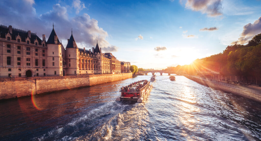
Set within the Seine near Quai de la Corse and just steps from Quai de Montebello, the island occupies an elongated river enclosure where stone embankments, mature trees, cathedral towers, judicial buildings and bridges separate the dense streets of the Right and Left Banks with a narrow band of water. Notre-Dame dominates the eastern half through its twin western towers and immense roofline as the Palais de Justice complex occupies much of the western interior behind stone fronts and enclosed courts. Quai aux Fleurs and Quai de l'Horloge trace the northern edge as Quai du Marché Neuf and Quai de Montebello expose the southern bank to broad views across the river. Short streets, planted squares and grand institutions create abrupt shifts in scale across ground measuring little more than a kilometer from end to end. The result is a concentrated historic core where the Seine, grand architecture and surviving street fragments compress more than two millennia of Parisian development onto a single island.
What defines Île de la Cité.
Île de la Cité is best known for becoming the fortified center of late Roman Lutetia before developing into the political and religious nucleus of medieval Paris. Archaeology complicates the traditional claim that the island was the original oppidum of the Parisii, since Julius Caesar placed Gallic Lutetia on a Seine island without establishing that site as the present Île de la Cité. Roman development is firmer: smaller river islands were joined during the first century AD, commercial activity gathered around a port and substantial residences occupied the resulting ground. Sections of the ancient quay survive beneath the cathedral forecourt, where excavations have also exposed baths and later construction. Pressure on Roman Gaul during the third century shifted strategic importance toward the defensible island, which received a fortified circuit in 308 built partly with stone reused from abandoned monuments and cemeteries on the Left Bank. A substantial fortified complex occupied the western end and later became associated with Emperor Julian, who was proclaimed Augustus by his troops in Lutetia in 360. Merovingian rulers subsequently used the territory before the Capetians established their royal palace there, turning the western island into a seat of monarchy. Louis IX intensified that role after acquiring the Crown of Thorns from Baldwin II of Constantinople in 1239 and further Passion relics in 1241. Sainte-Chapelle was constructed inside the royal palace in less than seven years to house that collection, with fifteen immense stained-glass bays carrying 1,113 panels through a building consecrated in 1248. The eastern island simultaneously developed around Notre-Dame after Bishop Maurice de Sully began the present cathedral in 1163, fixing royal authority at one end and episcopal authority at the other within the compact center of medieval Paris.
Nineteenth-century reconstruction changed the inhabited fabric between those historic poles on a scale unmatched since the Middle Ages. Before that intervention, narrow streets, houses, churches and charitable institutions occupied much of the ground around Notre-Dame, preserving a dense pattern accumulated across centuries. Excavations beneath the cathedral forecourt preserve the former Rue Neuve Notre-Dame, created during the medieval cathedral campaign and aligned directly with its central portal. Georges-Eugène Haussmann's restructuring swept away much of the central island during the Second Empire, replacing intricate blocks with larger institutional parcels and broad streets. Boulevard du Palais superseded the narrower Rue de la Barillerie, Rue de la Cité absorbed several older streets and the cathedral forecourt expanded dramatically through demolition around Notre-Dame. The present Hôtel-Dieu rose north of the enlarged parvis during the same reconstruction, and the barracks erected nearby became the Préfecture de Police. Archaeological excavations undertaken between 1965 and 1972 recovered successive strata beneath the new open ground, leading to creation of the Crypte archéologique in 1980. Excavation resumed on an exceptional scale in 2025 and 2026 across the Palais de Justice, Hôtel-Dieu and Notre-Dame forecourt, where work has exposed ancient and early medieval burials alongside further evidence for two thousand years of occupation. Île de la Cité consequently preserves not a frozen medieval center but a historic core repeatedly rebuilt above its predecessors, with the modern surface concealing Roman quays, fortifications, vanished streets and earlier institutions beneath the open spaces created during the nineteenth century.
How Île de la Cité fits.
Île de la Cité works as the anchor for a daytime exploration of its western end using three closely connected sites that move through Henri IV's reconstruction of the Seine crossing, an early seventeenth-century residential square and the planted point where the island narrows into the river.
Begin at Pont Neuf, authorized under Henri III in 1577 and completed under Henri IV in 1607 as a decisive departure from the inhabited medieval bridges of Paris. Its twelve stone arches crossed both channels of the Seine through the western point of the island, and its broad roadway omitted houses, opening views along the river that older bridge construction had obstructed. Semicircular refuges projected above the piers, creating places where pedestrians and street commerce occupied the bridge. An equestrian monument to Henri IV subsequently established the crossing as a royal site, binding the bridge to the Bourbon transformation of the western island. Continue to Place Dauphine, created by Henri IV after completion of Pont Neuf opened adjacent crown ground for development. The king granted the site to Achille de Harlay in 1607, and a triangular residential ensemble rose behind coordinated brick-and-stone facades whose narrow point addressed the royal monument. Houses originally enclosed the sides with repetitive elevations and commercial arcades below, extending the ordered urbanism developed around Place Royale into a smaller river setting. Demolition of the eastern range during the nineteenth century opened the triangle toward the Palais de Justice, yet surviving buildings at the western point retain the scale of the Bourbon scheme. Conclude at Square du Vert-Galant, the planted terrace beneath the equestrian statue at the island's western tip. Its ground descends from former river islets gradually attached to the larger island, including the Île aux Juifs, where Jacques de Molay, last grand master of the Knights Templar, was executed in 1314. Later embankment work consolidated the point beneath the bridge and royal square, and the present garden carries Henri IV's Vert-Galant sobriquet into the lowest public ground on the island. Trees and stone quays now frame the converging branches of the Seine at a point whose changing shoreline preserves the physical consequences of centuries of river engineering. The progression moves from Henri IV's completion of an unprecedented open bridge through the ordered residential development created beside it into the consolidated river ground beneath his monument, building a tightly connected account of how the western end of Île de la Cité acquired its present form.
Where your story begins.
Foresyte Travel reveals places that feel extraordinary long before you arrive.
Experience premium editorial crafted for luxury travelers.
Foresyte Travel may earn a commission when you book through the link on this page.














































































































