Why Phang Nga Bay matters.
Phang Nga Bay is a striking marine landscape where Phang Nga Province's Andaman Sea coastline meets ancient limestone karst formations, extensive mangrove ecosystems and the maritime traditions of southern Thailand's coastal communities.
Extending northeast of Phuket between the mainland shores of Phang Nga and Krabi provinces, Phang Nga Bay occupies a sheltered section of the Andaman Sea, with Phuket forming its western boundary, the Ko Yao islands separating its southern approaches and the mangrove-lined waterways near Phang Nga town defining its northern reaches. Hundreds of limestone formations rise from the shallow coastal waters, creating an intricate landscape of isolated towers, steep cliffs and densely vegetated islands. Narrow tidal channels penetrate the mainland mangrove forests, connecting sheltered estuaries with the open expanses of the bay. Vertical rock faces display pale limestone surfaces, darker mineral staining and deep recesses created by prolonged exposure to rainwater and marine erosion. Sea caves penetrate the larger islands, opening into enclosed lagoons surrounded by towering cliffs and tropical vegetation. Small fishing settlements occupy sheltered coastal locations, their timber structures and working boats establishing a human presence within the surrounding geological landscape. The result is an exceptional coastal environment whose dramatic limestone formations, protected waterways and traditional settlements create one of Southeast Asia's most distinctive maritime landscapes.
What defines Phang Nga Bay.
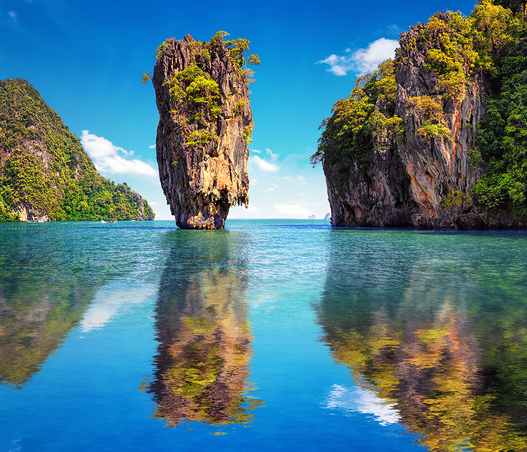
Phang Nga Bay is best known for its extensive limestone karst landscape, whose geological origins reach back to the Permian Period, when shallow tropical seas covered portions of the region that became southern Thailand. Marine organisms accumulated calcium carbonate sediments on the ancient seabed, eventually forming substantial limestone deposits through burial, compaction and geological cementation. Subsequent tectonic activity uplifted these formations, exposing them to tropical rainfall and initiating the prolonged dissolution of limestone along fractures, bedding planes and other structural weaknesses. The resulting karst landscape developed through successive periods of erosion and changing sea levels, creating isolated limestone towers, underground drainage systems and extensive cave networks. During the last glacial period, lower sea levels exposed substantial portions of the present seabed, connecting landmasses that subsequently became separated islands. Rising seas following the end of the last ice age inundated the lower coastal terrain, producing the distinctive drowned karst landscape visible throughout the bay. Archaeological discoveries within the surrounding limestone caves preserve evidence of prehistoric human activity, including rock paintings associated with ancient coastal communities. These paintings depict human figures, animals and other forms, contributing to the archaeological significance of the bay's sheltered rock formations. Coastal settlements subsequently developed around fishing, marine gathering and trade, taking advantage of the protected waterways and productive estuarine environments. Communities associated with the wider Malay Peninsula established enduring cultural and commercial relationships across the Andaman coast, connecting the bay with regional maritime networks. The development of tin mining across southern Thailand brought additional economic activity to the surrounding provinces, strengthening commercial connections between Phuket, Phang Nga and trading ports along the Strait of Malacca. Traditional fishing settlements continued to occupy sheltered locations, including the distinctive stilt-house community of Ko Panyi, whose residents maintained a maritime economy shaped by the surrounding waters. The bay entered international popular culture in 1974 when director Guy Hamilton used its limestone formations as a principal location for the James Bond film The Man with the Golden Gun, starring Roger Moore and Christopher Lee. The production featured Khao Phing Kan and the nearby limestone sea stack Ko Tapu as the fictional island hideaway of Francisco Scaramanga, introducing the landscape to a global cinema audience. The film's success established the enduring international nickname James Bond Island, contributing to the expansion of sightseeing excursions from Phuket and the surrounding coastal provinces. Thailand formally established Ao Phang Nga National Park on April 29, 1981, protecting 400 square kilometers of coastal waters, limestone islands and mangrove forests. The designation placed a substantial portion of the bay under national conservation management, recognizing the ecological importance of its marine habitats and distinctive geological formations. In 2002, the Phang Nga Bay Marine National Park area received international recognition under the Ramsar Convention as a wetland of international importance, acknowledging the significance of its mangrove ecosystems, intertidal habitats and coastal biodiversity. The Indian Ocean tsunami of December 26, 2004, caused widespread destruction along Thailand's Andaman coastline, affecting communities and tourism infrastructure across the surrounding region. Subsequent recovery and conservation initiatives strengthened attention to coastal resilience, marine ecosystems and the management of heavily visited natural areas. Phang Nga Bay's historical significance extends from ancient marine sedimentation and prehistoric settlement through regional maritime commerce, international cinema and the modern conservation of one of Thailand's most recognizable coastal environments.
Ao Phang Nga National Park's marine ecosystems develop around the relationship between shallow coastal waters, extensive mangrove forests and the complex limestone formations that shape the bay's tidal circulation. The northern shoreline contains substantial stands of mangrove vegetation, including species of Rhizophora and Avicennia adapted to saline and brackish environments. Their exposed root systems stabilize coastal sediments, provide shelter for juvenile fish and crustaceans, and create feeding habitats for birds associated with tropical estuaries. Mudflats emerge during lower tides, supporting populations of mollusks, crabs and other invertebrates that contribute to the surrounding food web. The protected waterways provide habitat for numerous fish species, with the interaction between mangrove forests and adjoining marine environments supporting the ecological productivity of the bay. Seagrass beds occupy suitable shallow-water areas, contributing to coastal biodiversity and providing feeding grounds for marine animals, including the vulnerable dugong. Limestone islands support another distinctive collection of habitats, with vegetation developing in pockets of soil accumulated along ledges, fissures and sheltered slopes. The steep cliffs provide nesting and roosting opportunities for birds and bats, whose populations depend on the relative isolation of the surrounding rock formations. Swiftlets occupy portions of the cave systems, connecting the bay to a longstanding Southeast Asian trade in edible bird nests. The limestone itself contains evidence of prolonged chemical weathering, with slightly acidic rainwater dissolving calcium carbonate and gradually enlarging fractures into passages and chambers. Stalactites develop where mineral-rich water deposits calcite along cave ceilings, and stalagmites form beneath persistent dripping points. Marine erosion modifies the lower portions of the islands, creating horizontal notches and openings whose development depends on tidal exposure and the mechanical action of water. Some cave passages lead into enclosed lagoons known locally as hongs, where collapsed cave roofs have created open-air chambers surrounded by nearly vertical limestone walls. These lagoons contain sheltered water and specialized vegetation, with access governed by the height of the tide and the dimensions of the surrounding cave entrances. Sea kayaking provides a distinctive means of exploring these formations, allowing small craft to navigate passages inaccessible to larger excursion boats. Guided paddling routes pass beneath low limestone ceilings before emerging into interior lagoons where the surrounding cliffs restrict views of the wider bay. The changing tidal conditions create substantial differences in access, with certain passages navigable only during suitable water levels. Beyond the cave systems, longtail boats maintain an important connection to the region's maritime heritage, their narrow hulls and exposed engines supporting transportation through shallow channels and between island communities. The bay's extensive sheltered waters also support larger excursion vessels, whose routes connect major geological attractions with traditional fishing settlements. The surrounding limestone formations create distinctive visual relationships through their isolated profiles, overhanging cliffs and vegetation-covered summits, establishing a landscape whose appearance changes substantially with viewing position and atmospheric conditions. Phang Nga Bay's natural distinction emerges through this intricate relationship between tropical karst geology, productive coastal ecosystems and maritime communities whose activities have developed around the sheltered geography of the Andaman Sea.
How Phang Nga Bay fits.
Phang Nga Bay works as the centerpiece of a maritime exploration connecting Thailand's celebrated limestone formations, the cultural heritage of its traditional fishing communities and the remarkable enclosed lagoons created by tropical karst erosion.
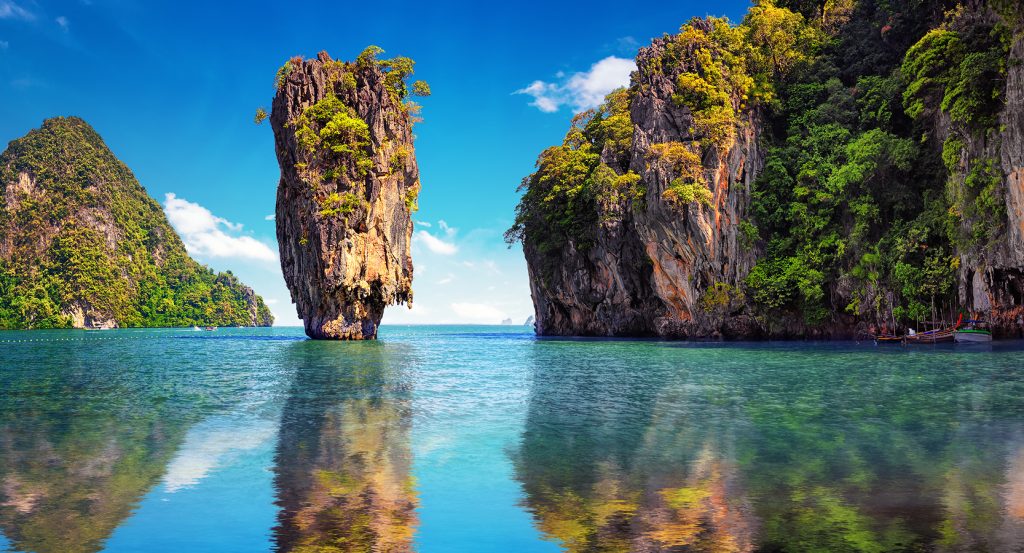
Begin at Khao Phing Kan, the limestone island internationally associated with the James Bond film The Man with the Golden Gun. Its Thai name refers to the distinctive leaning rock formations that characterize the island's geological structure. The adjoining sea stack of Ko Tapu rises twenty meters above the surrounding water, its narrow base supporting a broader upper section shaped by differential erosion. The isolated formation stands offshore from a small sandy cove, creating a distinctive visual relationship between the vertical limestone tower and the surrounding cliffs. The island's international recognition transformed it into one of the principal destinations for sightseeing excursions through the bay, establishing a direct connection between cinematic history and the region's natural landscape. Continue to Ko Panyi, the historic Muslim fishing village constructed on stilts beside a substantial limestone island. The settlement developed through maritime migration from the Malay Peninsula, with fishing families establishing homes above the shallow coastal waters. Timber walkways connect closely arranged houses, shops and community buildings, creating a compact settlement whose organization depends on the surrounding marine environment. A prominent mosque serves the community's religious life, preserving the Islamic traditions maintained by successive generations of residents. The village also contains a floating football pitch associated with its youth football culture, a distinctive feature that has attracted international attention. Its restaurants and seafood markets maintain connections with the fishing economy that supported the settlement's development. Conclude at Ko Hong, the limestone island distinguished by an enclosed tidal lagoon reached through a narrow sea-level passage. The island's geological structure incorporates steep limestone walls surrounding a sheltered interior basin, creating a natural chamber separated from the surrounding open water. Small kayaks navigate the connecting passage during suitable tidal conditions, entering a lagoon whose enclosed geography provides a distinctive perspective on tropical karst formation. Vegetation occupies ledges and sheltered areas above the water, and the surrounding rock faces display the effects of prolonged dissolution and marine erosion. The lagoon's restricted entrance contributes to its secluded character, creating a striking contrast between the broad waterways of the surrounding bay and the confined interior landscape. The progression moves from Khao Phing Kan's internationally recognized geological formations through Ko Panyi's maritime settlement heritage and culminates in Ko Hong's enclosed karst lagoon, connecting the natural and cultural features that distinguish Phang Nga Bay.
Where your story begins.
Foresyte Travel reveals places that feel extraordinary long before you arrive.
Enjoy editorial crafted for luxury travelers.
Foresyte may earn a commission when you book.