Why Bandelier National Monument matters.
Bandelier National Monument is an ancient archaeological preserve where the Pajarito Plateau's volcanic wilderness meets the architectural ingenuity of Ancestral Pueblo communities, whose cliff dwellings, ceremonial structures and cultivated landscapes preserve more than a millennium of human settlement in northern New Mexico.
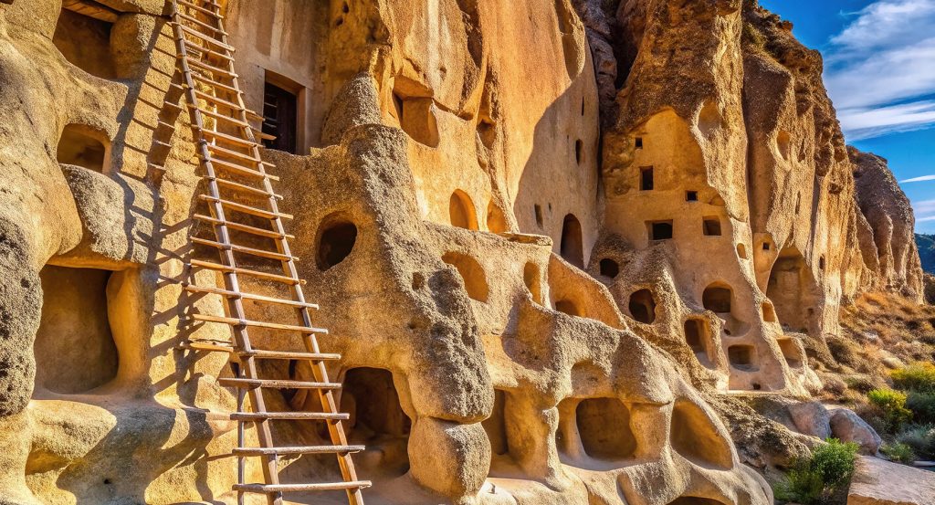
Situated northwest of Santa Fe near Los Alamos, the monument occupies a rugged section of the Pajarito Plateau between the Jemez Mountains and the Rio Grande Valley, encompassing deep volcanic canyons, forested mesas and the sheltered drainage of Frijoles Creek. Pale cliffs rise above the canyon floor, punctuated by excavated chambers, masonry ruins and natural cavities. Trails connect archaeological sites with riparian woodland, exposed rock faces and elevated viewpoints across the plateau. The surrounding terrain ranges from ponderosa pine forests to drier canyon slopes supporting juniper and piñon. The result is an extensive cultural landscape where volcanic geology, Indigenous architecture and protected wilderness reveal the enduring relationship between Pueblo communities and the environments of northern New Mexico.
What defines Bandelier National Monument.
Bandelier National Monument is best known for preserving Ancestral Pueblo cliff dwellings, masonry settlements and ceremonial structures within the volcanic canyons of the Pajarito Plateau. The plateau's geological foundations originated through enormous eruptions of the Jemez volcanic system, particularly the formation of the Valles Caldera more than one million years ago. Explosive eruptions deposited thick layers of volcanic ash and pumice across the surrounding landscape, producing the Bandelier Tuff that forms the monument's distinctive cliffs. Over time, erosion carved deep canyons into these deposits, exposing rock faces containing naturally formed cavities. Indigenous occupation of the wider region extends back thousands of years, with archaeological evidence of early hunting, gathering and seasonal settlement. Ancestral Pueblo communities established increasingly permanent settlements across the plateau during the twelfth century, developing agricultural systems adapted to the region's variable rainfall and elevation. By the thirteenth century, substantial communities occupied Frijoles Canyon and neighboring mesas, cultivating maize, beans and squash. Residents constructed masonry rooms against cliff faces and enlarged natural openings in the volcanic tuff to create additional living and storage spaces. The canyon's sheltered environment provided access to water, agricultural land and building materials. During the fourteenth century, settlement expanded into larger architectural complexes, including multistory residential structures and ceremonial spaces. The population eventually declined as communities migrated toward settlements along the Rio Grande and other regional centers. Modern Pueblo peoples, particularly the Cochiti and San Ildefonso communities, maintain ancestral and cultural connections with the plateau. Spanish colonial expansion introduced new political and religious pressures across northern New Mexico during the seventeenth century. Archaeological interest increased during the nineteenth century as scholars began examining the region's extensive architectural remains. Swiss-American archaeologist Adolph Bandelier investigated the area during the 1880s, contributing to early scholarly understanding of Pueblo settlement history. President Woodrow Wilson established Bandelier National Monument in 1916, protecting its archaeological resources under federal administration. The Civilian Conservation Corps subsequently developed trails, visitor facilities and infrastructure during the 1930s, establishing much of the monument's historic public-access structure. The National Park Service continues to manage the preserve as an archaeological and natural landscape, maintaining relationships with affiliated Pueblo communities whose histories remain inseparable from the protected sites.
Frijoles Canyon contains the monument's principal concentration of accessible archaeological structures, arranged along a narrow valley enclosed by steep volcanic cliffs. The Main Pueblo Loop Trail follows the canyon floor and lower cliff faces, connecting residential ruins with excavated chambers and ceremonial features. Tyuonyi, a substantial circular masonry settlement, originally contained hundreds of rooms arranged around central open spaces. Its architectural organization demonstrates the concentration of residential and communal activities within a compact settlement. The surrounding cliff walls contain cavates, chambers excavated or enlarged within the relatively soft volcanic tuff. These spaces served varied domestic and storage functions, with some retaining traces of plaster and architectural modification. Wooden ladders provide access to selected chambers along the visitor route, reproducing the vertical movement required to reach elevated openings. The Long House area preserves extensive masonry foundations and evidence of multistory construction against the canyon wall. Petroglyphs carved into exposed rock surfaces depict geometric forms, animals and other subjects associated with Pueblo cultural traditions. The Alcove House site occupies a substantial natural recess high above the canyon floor, reached by a steep trail incorporating ladders and stone steps. Its elevated setting contains architectural remains and a reconstructed ceremonial kiva, illustrating the use of protected cliff recesses for communal activities. Frijoles Creek supports cottonwood, willow and other riparian vegetation, creating a fertile corridor through the surrounding volcanic terrain. Agricultural fields historically extended across accessible canyon terraces and mesa surfaces, with cultivation adapted to local soil and moisture conditions. The monument's higher elevations support ponderosa pine forests, mixed conifer woodland and mountain ecosystems associated with the Jemez range. Wildlife includes mule deer, black bears and numerous bird species occupying the varied habitats. Wildfires and flooding have periodically altered the landscape, requiring continuing conservation of archaeological structures and visitor infrastructure. The monument's extensive trail system also reaches less accessible archaeological areas, preserving a broader perspective on settlement across the plateau. Its surviving architecture demonstrates the technical and social organization of communities that adapted volcanic geology to sustained agricultural occupation.
How Bandelier National Monument fits.
Bandelier National Monument works as the archaeological anchor for a northern New Mexico outing connecting Pueblo ceremonial architecture, the region's volcanic origins and the continuing cultural heritage of Indigenous communities along the Rio Grande.
Begin at Tsankawi, the detached archaeological district situated near the monument's northeastern boundary. The site preserves the remains of an Ancestral Pueblo settlement occupying an elevated volcanic mesa, with walking routes following deeply worn pathways cut into the soft tuff. Its archaeological features include masonry foundations, cavates and petroglyphs associated with generations of occupation. The mesa's exposed position provides extensive views across the Pajarito Plateau toward the surrounding mountain ranges. The worn trails preserve evidence of repeated movement between residential areas, agricultural fields and neighboring settlements. Continue to Valles Caldera National Preserve, the vast volcanic basin situated within the Jemez Mountains west of Los Alamos. The preserve encompasses the collapsed volcanic caldera created by enormous prehistoric eruptions, establishing the geological foundation for much of the surrounding plateau. Broad grassland valleys occupy the basin floor, enclosed by forested volcanic peaks and extensive geothermal features. Its protected landscape supports elk herds, mountain streams and high-elevation ecosystems. Interpretive programs examine the region's volcanic development and the cultural significance of the caldera to affiliated Indigenous communities. Conclude at San Ildefonso Pueblo, the historic Pueblo community situated along the Rio Grande northeast of Santa Fe. The community maintains cultural traditions rooted in centuries of occupation and ancestral connections with the surrounding plateau. Its artistic heritage includes the black-on-black pottery developed through the work of Maria Martinez and Julian Martinez during the early twentieth century. Their technical achievements transformed regional ceramic production through innovative firing and polishing methods grounded in Pueblo pottery traditions. The pueblo's continuing cultural practices establish a direct connection between contemporary Indigenous life and the ancestral settlements preserved across northern New Mexico. The progression moves from Tsankawi's mesa-top archaeological remains through Valles Caldera National Preserve's volcanic landscape and culminates at San Ildefonso Pueblo's continuing cultural traditions, connecting Bandelier National Monument with the geological and human history of the Pajarito Plateau.
Where your story begins.
Foresyte Travel reveals places that feel extraordinary long before you arrive.
Enjoy editorial crafted for luxury travelers.
Foresyte may earn a commission when you book.