Why Flatirons matters.
Flatirons is a dramatic sandstone formation where Boulder's western foothills meet the ancient geology of the Rocky Mountains, the preservation of Colorado's mountain landscapes and the climbing traditions that have shaped the city's outdoor culture.
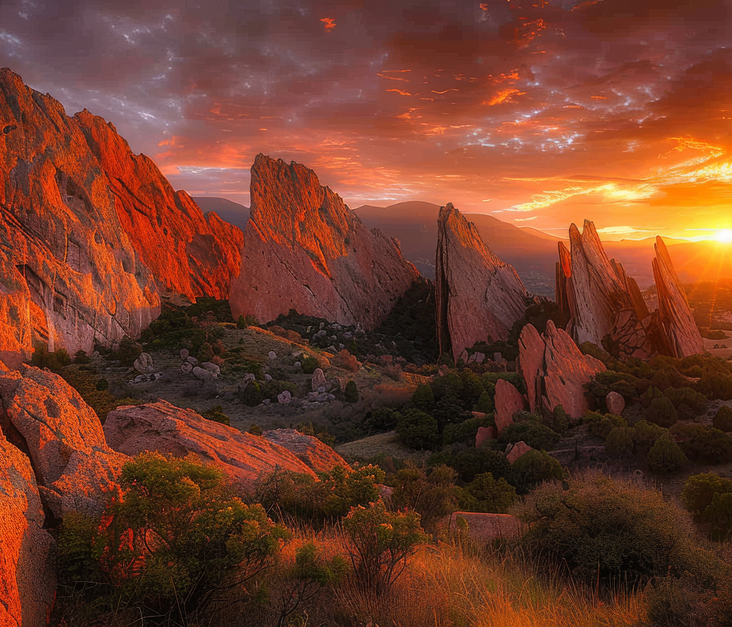
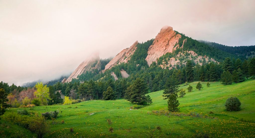
Set along the eastern slopes of Green Mountain near Baseline Road and just steps from Chautauqua Meadow, the formation rises above southwestern Boulder as a series of steeply inclined sandstone slabs separated by wooded gullies, rocky slopes and narrow mountain passages. Five principal Flatirons form the recognizable central group, their broad reddish surfaces emerging from ponderosa pine forests and grasslands beneath the higher summits of the Front Range. Hiking trails approach the formations through open meadows and mountain forests, with established climbing routes following cracks, ridges and expansive rock faces. Seasonal wildflowers, foothill wildlife, exposed geological strata and panoramic views across Boulder and the Great Plains contribute to the surrounding protected landscape. The result is a geological formation of exceptional visual distinction, scientific importance and enduring significance to Colorado's outdoor recreation culture.
What defines Flatirons.
Flatirons is best known for its five immense, tilted sandstone slabs, whose distinctive geometry establishes the western skyline of Boulder and provides one of the most recognizable geological profiles along Colorado's Front Range. The formations belong to the Fountain Formation, a sequence of sedimentary rocks deposited during the late Paleozoic Era as the ancient Rocky Mountains underwent extensive erosion. Their origins reach back 300 million years, when the Ancestral Rocky Mountains rose across portions of Colorado and surrounding regions. Rivers transported enormous quantities of gravel, sand and other eroded material eastward from those mountains, depositing thick layers of sediment along the margins of the ancient highlands. The accumulating deposits gradually hardened into sandstone and conglomerate, preserving fragments of the mountains from which they originated. Iron-bearing minerals contributed to the reddish coloration characteristic of the exposed rock. Subsequent geological periods brought additional sedimentation as the region passed through changing environments that included coastal plains, deserts and shallow seas. Layers of younger rock accumulated above the Fountain Formation, burying the ancient deposits beneath an extensive sedimentary sequence. A major episode of mountain building beginning 70 million years ago initiated the uplift responsible for the modern Rocky Mountains. Known as the Laramide Orogeny, this tectonic event raised ancient crystalline rocks and tilted the overlying sedimentary formations along the eastern mountain front. The sandstone beds forming the Flatirons were inclined 50 degrees toward the east, creating the steeply sloping surfaces that distinguish the formations. Erosion subsequently stripped away substantial quantities of overlying material, exposing the resistant sandstone slabs and separating them from softer surrounding rock. Their triangular profiles developed through the relationship between the tilted geological layers, the underlying mountain slopes and the erosion of intervening material. The Fountain Formation also appears at Red Rocks near Morrison, Roxborough State Park and Garden of the Gods, connecting Boulder's formations with a wider geological history across the Front Range. The Flatirons' familiar name emerged during Boulder's early settlement period, when residents associated the broad rock surfaces with the flat metal irons used for pressing clothing. Earlier names included the Chautauqua Slabs and the Crags, reflecting the formations' close geographical relationship with the cultural and recreational landscape developing at their base. The five principal formations are numbered from north to south, beginning with the First Flatiron and extending through the Fifth Flatiron along Green Mountain's eastern slopes. Additional named formations, including the Seal, Devil's Thumb and the Matron, contribute to the surrounding geological complex. Their scientific importance emerges from the extraordinary visibility of ancient sedimentary processes, tectonic uplift and erosion within a landscape that has become inseparable from Boulder's geographical character.
How Flatirons fits.
Flatirons works as the geological centerpiece for a Boulder itinerary connecting the city's protected foothills with the historic institutions, mountain landscapes and recreational traditions that define its relationship with the Rocky Mountains.
Begin at Chautauqua Park, the historic recreational landscape occupying the eastern base of the Flatirons along Baseline Road. The park developed through the Colorado Chautauqua movement, which established an educational and cultural gathering place in Boulder in 1898. Its broad meadow provides unobstructed views of the sandstone formations, with surrounding trails connecting the historic grounds to the protected mountain landscape. The Colorado Chautauqua includes preserved cottages, an auditorium and institutional buildings associated with the late nineteenth-century movement for public education, cultural programming and outdoor recreation. The surrounding district's National Historic Landmark designation recognizes its importance within the history of American educational and recreational institutions. Continue to Flagstaff Mountain, the prominent foothill summit rising west of Central Boulder. Its slopes contain extensive stands of ponderosa pine, exposed rock formations and established hiking routes connecting the mountain with the surrounding open space system. Flagstaff Road climbs through the foothills toward several overlooks, providing elevated perspectives across the city, the Great Plains and neighboring mountain ridges. The summit area contains exposed Boulder Creek granodiorite, an ancient crystalline rock formed 1.7 billion years ago during an earlier episode of mountain building. Its geological character provides a compelling counterpart to the younger sedimentary formations visible along Green Mountain. Conclude at National Center for Atmospheric Research, the scientific institution occupying a distinctive building on Table Mesa southwest of Central Boulder. Architect I. M. Pei designed the Mesa Laboratory, whose concrete towers and geometric forms draw inspiration from the expansive architecture and geological landscapes of the American Southwest. Completed during the 1960s, the complex became a prominent center for atmospheric science, climate research and the study of Earth's interconnected physical systems. Public exhibits and surrounding trails connect the institution's scientific mission with the natural environment of the Front Range. The building's elevated setting provides extensive views across Boulder and the surrounding foothills, establishing a relationship between scientific inquiry, architecture and the mountain landscape. The progression moves from the historic cultural grounds beneath the Flatirons through the ancient crystalline geology of Flagstaff Mountain and culminates in the atmospheric research institution overlooking Boulder's protected western landscape.
Where your story begins.
Foresyte Travel reveals places that feel extraordinary long before you arrive.
Enjoy editorial crafted for luxury travelers.